Click here to read this mailing online.
Here are the latest updates for nurhasaan10@gmail.com "Free Technology for Teachers" - 2 new articles
Getting Started With Microsoft FlipBack in June Microsoft threw a big party to announce that they were rebranding Flipgrid. What was once called Flipgrid is now Microsoft Flip. Fortunately, not much else changed and all of my favorite Flipgrid features still work. That said, some people have already been asking me for tutorials about Microsoft Flip. That's why I created this new tutorial on getting started with Microsoft Flip. In Getting Started With Microsoft Flip you'll see:
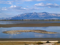
Watch the video on my YouTube channel or as embedded below. Timelapse and Virtual Field Trip - The Great Salt LakeThis morning my attention was grabbed by a BBC video titled Utah's Great Salt Lake is Running Out of Water. It's a fascinating video about the conditions that have contributed to the Great Salt Lake shrinking by nearly two-thirds in this century. Spoiler alert: drought isn't the biggest contributor to the shrinkage. Watching the BBC's video about Great Salt Lake prompted me to do a little searching for more information about the lake and its ecosystem. That search led me to a few things worth sharing with students. In Google Earth you can view timelapse imagery of Great Salt Lake. In the desktop version of Google Earth you can view imagery dating back to the 1970s. In the web version of Google Earth you can view imagery dating back to the1980s. Both will let you see the shrinking shoreline of the lake over the last few decades. Here's a short Google-produced video of the timelapse imagery of Great Salt Lake. On a related note, here's how to find timelapse imagery in Google Earth. Last year The Natural History Museum of Utah produced Virtual Field Trip - Great Salt Lake. This ten minute video that takes students from the origins of Great Salt Lake through today. Along the way students can learn about changes to the lake's water level and ecosystem. The Genetic Science Learning Center hosted by the University of Utah offers a handful of resources for helping students learn about the Great Salt Lake ecosystem. Those resources include an interactive food web, an interactive brine shrimp lifecycle display, and an interactive map of Great Salt Lake microenvironments. On related notes, I'll be speaking in Salt Lake City in August. And if you'd like to learn more about using Google Earth in your classroom, join me on August 2nd for a webinar titled To Geography & Beyond With Google Earth and Google Maps. More Recent Articles |
Next
« Prev Post
« Prev Post
Previous
Next Post »
Next Post »


ConversionConversion EmoticonEmoticon