Click here to read this mailing online.
Here are the latest updates for nurhasaan10@gmail.com "Free Technology for Teachers" - 3 new articles
Winter, Animals, and Fun - The Week in Review As I look toward the end of the year I'd like to say a big thank you to all of you who have supported my work throughout this year and year's past (some of you have been with me for more than decade). Whether you've purchased one of my courses or ebooks or you've simply shared my blog posts with your friends and colleagues, your support is appreciated. These were the week's most popular posts:1. A New Way to Add Students to Flipgrid 2. How to Modify & Share Canva Templates 3. Six Reasons to Try Tract for Remote & Hybrid Learning 4. A Platypus in My House! Fun and Learning Through Augmented Reality 5. How to Use Google Keep as a Comment Bank 6. Nine Interactive Maps Depicting the History of the United States 7. 21 Activities and Lessons That Have a Winter Theme Thank you for your support! Your registrations in Practical Ed Tech courses (listed below) and purchases of my ebook help me keep Free Technology for Teachers going. On-demand Professional Development
Other Places to Follow Me:
Building the Hoover Dam - A New TED-Ed Lesson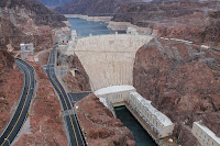  Despite already knowing the history of the construction of the dam, I still found the video entertaining and informative. Overall, it's a good summary of the dam's construction. You would need to look elsewhere to really dive into the engineering of the dam or the environmental impact of the dam. Of course, I can't think of the Hoover Dam without also thinking of the famous dam tour scene in National Lampoon's Vegas Vacation and The Highwaymen performing The Highwayman. 4,000+ Maps of Military Battles and Campaigns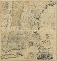 The LOC's collection of maps of military battles and campaigns contains more than 4,000 maps that are free to view, download, and reuse. The vast majority of the maps are from the 18th and 19th centuries although there are about 600 maps covering World War I and II. You can browse through the collection according to date, location, subject, and language (most of the maps are in English or French). Once you've found a map that seems interesting, click on it to view more information about the cartographer and a little backstory on the map. Most of the maps can be downloaded as images and some can be downloaded as PDFs. Applications for EducationMy first thought when looking through the collection was to download the maps to use as overlays in Google Earth. Doing so can provide students with some geographic context and comparisons for military battles and campaigns that they're learning about in U.S. History classes. Directions for overlaying historic maps onto Google Earth can be found in this video.  If you're interested in learning more about using Google Earth and Google Maps in your classroom, enroll in my self-paced Crash Course in Google Eath & Maps for Social Studies. More Recent Articles |
Email subscriptions powered by FeedBlitz, LLC • 1800 Camden Road, Suite 107-258 • Charlotte, NC 28203, USA
This is dummy text. It is not meant to be read. Accordingly, it is difficult to figure out when to end it. But then, this is dummy text. It is not meant to be read. Period.
« Prev Post
Next Post »
ConversionConversion EmoticonEmoticon